


About Us
Executive Editor:Publishing house "Academy of Natural History"
Editorial Board:
Asgarov S. (Azerbaijan), Alakbarov M. (Azerbaijan), Aliev Z. (Azerbaijan), Babayev N. (Uzbekistan), Chiladze G. (Georgia), Datskovsky I. (Israel), Garbuz I. (Moldova), Gleizer S. (Germany), Ershina A. (Kazakhstan), Kobzev D. (Switzerland), Kohl O. (Germany), Ktshanyan M. (Armenia), Lande D. (Ukraine), Ledvanov M. (Russia), Makats V. (Ukraine), Miletic L. (Serbia), Moskovkin V. (Ukraine), Murzagaliyeva A. (Kazakhstan), Novikov A. (Ukraine), Rahimov R. (Uzbekistan), Romanchuk A. (Ukraine), Shamshiev B. (Kyrgyzstan), Usheva M. (Bulgaria), Vasileva M. (Bulgar).


 PDF
p. 51-54
PDF
p. 51-54
Introduction
The geological section´s top slice forecasting (GSTS forecasting) is a process of obtaining the knowledge about the detailed GSTS structure from the geophysical data [1]. It occurs in different civil and industrial engineering tasks. For this purpose various associations between geophysical parameters and other physical properties of rocks are established. That means, that geological environment is not breached as geophysical methods are applied on its surface.
But the process of forecasting GSTS is quite difficult because the associations include various parameters which can be defined only by special tables on the basis of some other properties of rocks. Besides, all those associations and tables are developed on the basis of a huge amount of statistic data and are constantly specified.
In general, to forecast GSTS we must apply a complex of methods including 1 or 2 geophysical methods and laboratory analysis. Thus, it takes a lot of time and money to conduct engineeringgeologic researches.
On the other side, there are high-qualified specialists who have great experience and are able to obtain maximum of knowledge from minimum of data. They are called professionals. They possess unique knowledge and experience in their speciality. But it is obvious that the experience of one man can be perceived by another man in another way or even rejected.
AI-systems are the solution of both problems: GSTS forecasting with less time and finances, and saving the unique knowledge of the professionals in the field of engineering geology. To demonstrate the abilities of intellectual systems in GSTS forecasting the program for rocks identifying was developed.
1. Rocks Identification
The program´s structure is shown on the Fig. 1. The knowledge-base editor is divided into 3 subprograms:
- Geophysical Methods subprogram allows entering and editing the knowledge about geophysical methods in engineering geology;
- Rocks Classifier subprogram allows entering and editing the knowledge about the rocks;
- Rules subprogram allows entering and editing the rules that are used to identify the rocks.
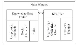
Fig. 1. Program structure
To identify the rocks the user may choose one of two subprograms: Engineering-Geological Classifier or Kirkham´s Triangle. The existence of these two subprograms is a consequence of the key problem of identifying rocks: there is no unified classifier. Of course, there is GOST 25100-95 «Rocks. Classifier», but it should be formalized first and the tables in it are not related to each other.
1.1. Engineering-Geological Classifier
The structure of engineering-geological classifier (EGC) of rocks is shown on the Fig. 2. It includes five groups of rocks. For each of the groups there are a properties description and a list of rocks types. The group «V - Rocks of specific properties» requires special research methods and is not presented in this paper.
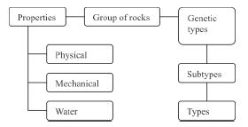
Fig. 2. The structure of EGC
It was noticed that each rocks group can be identified almost uniquely by two properties: elastic waves´ speeds and density of rocks (Table 1). Thus, with these two properties and
the knowledge of how they are interrelated with rocks types there is no need to apply a lot of engineering-geological methods to forecast GSTS.
Table 1. The interrelation between rocks groups (EGC) and their elastic waves´ speeds and densities
|
Group of rocks |
Elastic waves´ speed Vp , m/s |
Density ρ, g/sm3 |
|
I - Hard rocks |
4000-8000 |
2,65-3,10 |
|
II - Rather hard rocks |
1100-4500 |
2,20-2,65 |
|
III - Loose soils |
200-1800 |
1,40-1,90 |
|
IV - Soft soils |
300-2200 |
1,10-2,10 |
Back to the subprogram, the user must enter the values of elastic waves´ speeds and densities of rocks, and the subprogram identifies the rocks group for each pair of input data according to Table 1 formalized in rules. But it should be mentioned that using EGC the program can identify only 4 rocks groups.
1.2. Kirkham´s Triangle
US Department of Agriculture textural classification triangle (after D. Kirkham) is shown on the Fig. 3 [2]. As it is well-seen, to identify the rocks type we must know three rocks parameters: silt, clay and sand percentage (granulometric com-position). But the input data are elastic waves´ speeds and densities of rocks. To establish associations between the input data and granulometric composition, the statistic data were used. The result is presented in Table 2 (columns 1-2 - association between density and silt percentage; columns 3-4 - association between elastic waves´ speed and sand percentage).
Thus, the user enters the values of elastic waves´ speeds and densities of rocks. The subprogram associates the input data with granulometric composition according to Table 2 formalized in rules and identifies the rocks types for each pair of the input data according to Kirkham´s triangle for-
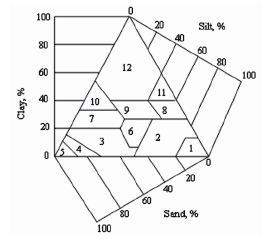
Fig. 3. Kirkham´s triangle: 1 - silt; 2 - silt-loam; 3 - sandy loam; 4 - loamy sand; 5 - sand; 6 - loam;
7 - sandy clay loam; 8 - silty clay loam; 9 - clay-loam; 10 - sandy-clay; 11 - silty clay; 12 - clay
Table 2. Associations between input data and granulometric composition
|
Density, g/sm3 |
Silt, % |
Elastic waves´ speed, m/s |
Sand, % |
|
1 |
2 |
3 |
4 |
|
1,4-1,5 |
30-50 |
200-350 |
80-90 |
|
1,51-1,55 |
20-30 |
351-450 |
50-70 |
|
1,56-1,65 |
10-20 |
451-500 |
40-50 |
|
1,66-2,0 |
0-10 |
501-670 |
20-40 |
malized in rules. It should be mentioned that meanwhile there is no appropriate association for clay percentage. It can be established in two possible ways: 1) the third input parameter interrelated with clay percentage should be found; 2) clay percentage associates with both input parameters.
2. Experiment
To test the program the data of engineeringgeological researches in Irkutsk city were used. The input data and the program´s results are presented in Table 3 (columns 1-4). In the column 5 the results obtained by standard engineering-geological methods are presented. As it is well-seen, the program identified rocks types correctly in 86 % of cases.
Conclusions
The rocks identification accuracy of 86 % is a very good efficiency and perspectivity factor for applying the knowledge-based systems in GSTS forecasting.
Using rules to formalize the unique knowledge of professionals in any human activity field
Table 3. Testing data and results
|
№ |
Density, g/sm3 |
Elastic waves´ speed, m/s |
Program´s result |
Fact |
|
1 |
2 |
3 |
4 |
5 |
|
1 |
1,882 |
350 |
Loamy sand |
Loamy sands, loams |
|
2 |
1,766 |
410 |
Sandy clay loam |
|
|
3 |
1,7776 |
320 |
Loamy sand |
|
|
4 |
1,7428 |
400 |
Sandy clay loam |
|
|
5 |
2,0 |
430 |
Sandy clay loam |
|
|
6 |
1,8008 |
480 |
Sandy clay loam |
|
|
7 |
2,0 |
510 |
Clay |
|
|
8 |
1,9748 |
470 |
Sandy clay loam |
|
|
9 |
1,534 |
370 |
Sandy loam |
Loams, silty sands, sands |
|
10 |
1,534 |
360 |
Sandy loam |
|
|
11 |
1,6848 |
390 |
Sandy clay loam |
|
|
12 |
1,7312 |
430 |
Sandy clay loam |
Loams |
|
13 |
1,476 |
430 |
Sandy loam |
|
|
14 |
1,6732 |
430 |
Sandy clay loam |
|
|
15 |
1,6036 |
430 |
Sandy loam |
|
|
16 |
1,6616 |
430 |
Sandy clay loam |
|
|
17 |
1,5688 |
430 |
Sandy loam |
|
|
18 |
1,6616 |
430 |
Sandy clay loam |
|
|
19 |
1,6964 |
430 |
Sandy clay loam |
|
|
20 |
1,5804 |
430 |
Sandy loam |
|
|
21 |
1,5224 |
380 |
Sandy loam |
|
|
22 |
1,6152 |
380 |
Sandy loam |
|
|
23 |
1,6732 |
380 |
Sandy clay loam |
|
|
24 |
1,6268 |
380 |
Sandy loam |
|
|
25 |
1,4296 |
380 |
Sandy loam |
|
|
26 |
1,6964 |
380 |
Sandy clay loam |
|
|
27 |
1,708 |
380 |
Sandy clay loam |
|
|
28 |
1,5224 |
380 |
Sandy loam |
|
|
29 |
1,7196 |
380 |
Sandy clay loam |
|
(as it is shown on the example of solving engineering-geological tasks) we can collect, keep, transfer and use them. And with this unique knowledge the AI-systems can acquire a certain intuition in solving different problems.
References
- Dmitriev A.G. The geological section´s top slice forecasting by the high-resolution multiwaves seismic methods, ISTU publishing house. - Irkutsk, 1995.
- McNeill J.D. Electrical Conductivity of Soils and Rocks. - Technical Note TN-5, 1980.
The work is submitted to the scientific international conference «Scientific Research of Higher School on Priority Orientations of Science and Technology», (Amsterdam - Amsterdam), 15-26 June, 2010, came to the editorial office on 18.05.2010.
Musikhina O.M. APPLYING THE KNOWLEDGE-BASED SYSTEMS TO THE GEOLOGICAL SECTION’S TOP SLICE FORECASTING. International Journal Of Applied And Fundamental Research. – 2011. – № 1 –
URL: www.science-sd.com/387-23469 (23.07.2026).